
 Yahoo Finance
 Famously rainy Seattle breaks its fall rain record after a summer of extreme heat
The city accumulated nearly 19 in of rain between September and the end of November, a stark contrast to the summer’s searing temperatures
Seattle area, notorious for its wet, overcast days, has logged its rainiest fall season on record after weeks of back-to-back downpours, capping a year of weather whiplash that saw the region endure a record breaking heatwave over the summer.
Between September and the end of November, the Seattle metropolitan area accumulated about 19 in of rain, the largest amount since records began in 1945 and surpassing its previous record chronicled in 2006 by less than an inch, according to Matthew Cullen, meteorologist at the National Weather Service forecast office in Seattle.
Related: ‘Atmospheric rivers’ threaten new floods in hard-hit Washington state
Unlike Seattle’s more typical drizzles, the recent rain has been far more torrential and engulfed the city, especially severely in late October and for several days in a row in mid-November.
Cullen explained that there have been a series of “atmospheric rivers” or narrow bands of moisture in the atmosphere that have traveled across the Pacific Ocean and ended up aimed over the area, unloading heavy rain over narrow areas, “almost like a fire hose”.
“It’s our wettest time of year, and it’s very common to get several of these systems in a row,” said Cullen. “What is a little less common has been just the back-to-back intensity.”
The extreme rainy season comes in a year that has seen Seattle and the surrounding area besieged by unusual weather events, including a historic heatwave over the summer.
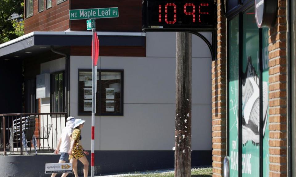
In late June, the city reached a record-breaking 108F (42C) after a deadly “heat dome” engulfed the region. At the same time, for much of the summer, Seattle was extremely dry, going 51 days without measurable rain – tied with 1951 as the second longest period on record. Just weeks later, its record-breaking rainy autumn would begin.
These whiplash-inducing extremes have left lasting marks on an area known for its moderate weather.
The scorching temperatures, which experts said were exacerbated by global heating, resulted in more than 100 people dead in Washington state, crops destroyed and salmon covered in angry red lesions and white fungus. The dry conditions also left lands vulnerable to fires, which were recorded in several areas across Washington.
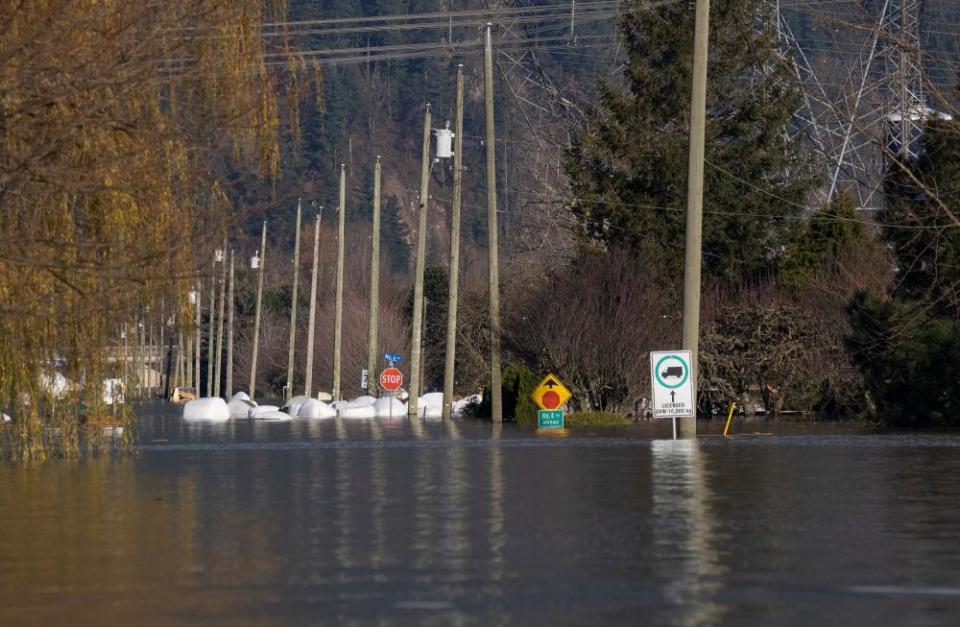
The recent heavy rains caused some road closures in Seattle. But in cities farther north, near the Canadian border, the impact was much greater. In Whatcom county, dozens of roads were closed due to flooding and some residents had to be evacuated. The Lummi Reservation, which is also in that area, was cut off when its roads were overtaken by water.
Across the border in Canada, heavy rains and winds in British Columbia have resulted in flooding, landslides and thousands of evacuations. Mike Farnworth, minister of Public Safety and solicitor general, described the situation as “utter devastation”.
On 15 November, Washington’s governor Jay Inslee issued a severe weather state of emergency in King county, which includes Seattle, and 14 other counties across the state in response to the heavy rain and flooding.
Nick Bond, state climatologist for Washington, explained that the back-to-back La Niña conditions, a climate pattern that can disrupt weather throughout the world, could be causing the rainfall. He said climate change was likely also a factor, since warmer air is able to hold more water vapor compared with cooler air.
“As the climate has warmed, then it means when everything comes together, and when conditions are right to produce precipitation, that it comes down that much harder,” he said.
The question now is whether these extreme weather conditions could be an indication of what the region will experience in the future.
Karin Bumbaco, University of Washington research scientist and Washington’s assistant state climatologist, said these types of extreme weather events could become more typical.
“This is a preview of what could be a normal year a couple decades down the road,” she said. “This year fits the pattern of what we expect to see in the changing climate with wet fall, following an especially dry summer.”
Bond said it’s important to look at the weather over the past year, figure out what happened and what can be done about it. He explained that one major takeaway is recognizing that future water problems “are not necessarily the amount of water but the timing of the water. Too much when we don’t need it as much and too little when we really need it.”
The area has historically relied on mountain snowpack to get through the dry season. But with temperatures warming moving forward, in some cases the snowpack won’t be as healthy as it once was. So, he recommended looking into boosting reservoir capacity, and even ways to store water in groundwater.
“Hopefully we can learn from this,” he said. “And I’m sure we are. And how do we go forward anticipating that this sort of stuff is going to continue to happen, and that we can do something about it. There’s always going to be some hardships. But that doesn’t mean that you can’t minimize the hardships.”
