
 Yahoo Finance
Google made a huge change to the way Google Maps look
Google has reduced the number of cities it shows in Google Maps by up to 83%, according to Justin O'Beirne, while vastly increasing the number of roads it shows on the maps. O'Beirne is a former Apple employee who works on that company's maps app. He is also an author who writes about digital maps and how they are designed. He has a book on the topic coming out later this year.
In a blog post about the way Google has changed the design of its maps, O'Beirne provided these side-by-side screen shots of Google maps from 2010 and today:
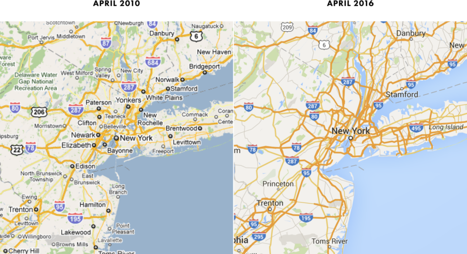
Google / Justin O'Beirne
You can see that Google has largely abandoned labelling towns and cities in favour of showing as many roads as it can. O'Beirne believes this makes the maps more confusing and less useful.
However, he also has a theory as to why the change was made: Mobile phones. After 2010, mobile usage of Google Maps vastly exceeded desktop usage, and the little town names can clutter a map on a phone screen. So it looks as if Google simply removed them.
Read O'Beirne's entire discussion of Google Maps design here.
NOW WATCH: Only in San Francisco — inside the 232-square-foot micro apartment that sold for nearly $425,000
See Also:
