
 Yahoo Finance
 Next-Gen Geospatial, AI, and Other Tech Is Critical for Utilities to Mitigate Wildfires
The danger of wildfires has risen dramatically over the past two decades as more extreme temperatures and more volatile weather patterns have increased the frequency and intensity of fires. The most prominent examples of this have been in the western U.S. and Canada, but wildfire risks are rising in every geographic area of North America. Everyone who reads POWER is aware of the risks and operational challenges these climate change-driven risks are posing for electrical utilities. Utilities understand the responsibility they have to protect public safety. And that internal pressure has been heightened by external pressure from public utility commissions that are imposing tighter regulations aimed at reducing the risk of wildfires caused by utility infrastructure (Figure 1).
A Turning Point for the Industry
Wildfire mitigation has always been important to utilities, particularly in the West, but it took on a much higher level of importance after the Dixie Fire in 2021. That fire was sparked by an untrimmed tree limb coming in contact with a live power line during high-risk conditions in northern California. The American West had already suffered through years of wildfires that were increasing in frequency and intensity, including the summer of wildfires in 2020 that blanketed so much of California, Oregon, Washington in thick smoke. Then came the Dixie Fire the following summer, which burned nearly a million acres, destroyed multiple towns, and prompted record-breaking lawsuits. [caption id="attachment_220023" align="alignnone" width="640"]
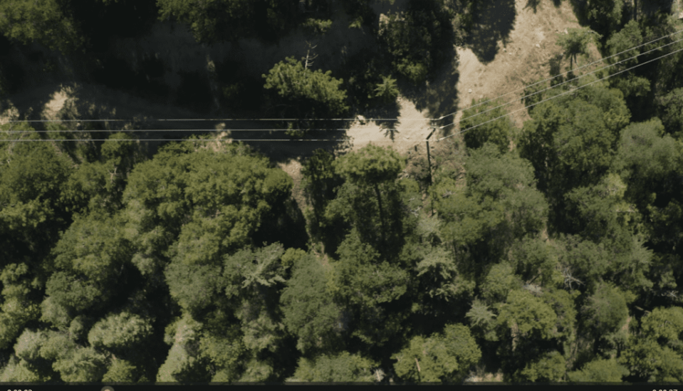
1. Power lines that are close to vegetation need to be maintained to help mitigate the potential for wildfires from faulty equipment, or damage to the lines that could spark a fire during extreme weather events. Source: Locana[/caption] That fire was a turning point for the utility industry. Over the past three years since that fire, utilities have collectively invested billions of dollars into large-scale vegetation management and fire prevention initiatives. These efforts have involved armies of field crews doing on-site inspections, assessing risks and performing vegetation management on a massive scale over huge geographic areas—all supported by Geographic Information System (GIS) departments analyzing as much visual data as they can process to support those field crews.
A More Sustainable Approach to Mitigation
Devoting this scale of financial resources and human power to the issue was understandable in the wake of the Dixie Fire, and weather conditions that have continued to set records, including temperatures of 116 degrees in Sacramento, California, in 2022; a record-shattering September temperature of 104 degrees in Salt Lake City, Utah, in 2022; and 108 degrees in Portland, Oregon, in 2023. The conditions that raise the risk of wildfires clearly aren’t going away. But there needs to be a more fiscally, operationally sustainable way for utilities to tackle this challenge. The “brute force” approach that has dominated since the Dixie Fire needs to evolve into something with more precision, such as an approach that enables utilities to deploy limited resources in the optimal way, to maximize the impact of their mitigation efforts in the face of challenges such as vegetation encroachment and aging infrastructure. Luckily, precision is at the heart of new best practices for wildfire mitigation being implemented by a number of the utilities working with Locana and other groups on mitigation efforts. It is being driven by the use of advanced geospatial systems in combination with technologies like mobile tablets (Figure 2), computer vision and generative artificial intelligence (AI). This combination of technologies is giving field crews, department heads, GIS departments and senior decision-makers the ability to be far more precise with their mitigation efforts—driven by data and insights that are richer, more easily accessible, and easier to translate into decisions and actions. [caption id="attachment_220024" align="alignnone" width="640"]
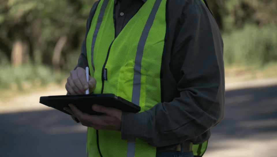
2. Work crews can use mobile tablets and other devices to access data that supports field maintenance of power infrastructure. Source: Locana[/caption]
Next-Gen Geospatial and Location Intelligence
Geospatial technology has long had a small but important role to play in vegetation management, which is a centerpiece of wildfire mitigation. Small GIS departments have a long and proud history of providing mapping, geo-location and visualization that supports effective vegetation management efforts. Today, next-gen geospatial tools are able to have an even bigger impact by providing:
A more consolidated solution approach to delivering vegetation management systems. Better capability for real-time, active integrations between systems.
More adaptable to cloud based or hybrid solutions allowing for a more integrated solutions with vegetation maintenance contractors.
Increased adoption of mobile devices/platforms allowing for higher populations of incident collectors and more opportunities for reporting.
And collaboration with AI to drive faster insights that can be consumed and acted upon even by workers with no familiarity with geospatial technology.
Geospatial technology today has the ability to play a key role in wildfire mitigation because it delivers critical intelligence and actionable insights from the massive volume of data (Figure 3) that utilities have access to from their infrastructure, mobile tablets, sensors, GIS systems, operational databases, satellites, and more. It has the power to drive faster, more informed, more effective decision making. And that is critical to performing wildfire mitigation in a way that is both successful and more precise. [caption id="attachment_220025" align="alignnone" width="640"]
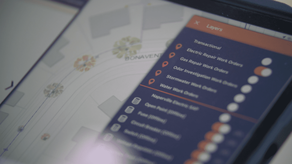
3. Utilities have a wealth of data available to support maintenance of assets across their territory. Source: Locana[/caption]
More Effective Triage in the Field
A great example of geospatially-driven precision is the way work crews in the field can perform faster, more successful triage when they are in a forested area. Using location-based data and computer vision on their computer tablets, work crews can far more quickly identify dangers, prioritize them and take action with vegetation management. Plant identification is a perennial challenge for field crews. Many trees and plants look quite similar to one another (Figure 4) yet have far different growth patterns and pose far different dangers to infrastructure. [caption id="attachment_220026" align="alignnone" width="640"]
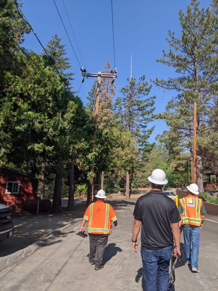
4. Field crews need to be able to identify vegetation that could pose a risk to power transmission infrastructure. Source: Locana[/caption] That is particularly true when plants and trees are early in their lifecycle before they make large jumps forward in size. One plant that is 10 yards away from the edge of a buffer area around a high-power transmission line might be low risk as it grows, while another that looks very similar poses a high risk when it is the same distance away. To reduce the chances of mis-identification, mobile tablets can be equipped with computer vision that enables accurate plant identification so workers can decide where to focus their trimming. Another example is in areas where insect infestation creates risks that are difficult to assess with the naked eye. Spectral and non-spectral imaging collected from remote sensors can be used to detect problem areas. Results from these advanced analytics can be delivered on mobile mapping solutions to help direct work crews in real-time, on-site, and advance mitigation planning by eliminating potential threats before they become incidents. It’s a recipe not only for better decision-making but higher productivity, which is critical when these changes could mean that a work crew could potentially address three sites in a day instead of just two. That is a huge magnification of the efficacy of crews. This triage process can also be aided by computer vision-guided measurements, which are far more accurate than the naked eye at measuring how close vegetation is to infrastructure. Workers can also tap into the latest real-time visual information delivered by drones and satellites to achieve far more precise risk assessments that what has been available in the past. The result is less guesstimation and much more highly precise information. This is particularly important as more utilities roll out protocols for certain risks that demand immediate action by crews, where response times are monitored, and where work crew leaders may not be allowed to leave the scene until remediation is complete. Speed and precision make an enormous impact.
Real-Time Alerts About Risks
These technologies are enabling utilities to be much more effective at knowing when and where to deploy work crews. Next-gen geospatial systems are able to identify and anticipate high-risk situations with a speed that is remarkable. Spotting these dangers purely from work crews would be impossible. The prior generation of geospatial technology allowed this analysis to be done in weeks using the analysis of experts in the GIS department. That was a huge step forward. But today, the analysis can be done in minutes, allowing utilities to make much faster decisions about exactly where to send their crews. By linking the insights from this geospatial analysis with insights from the investments they have made into remote monitoring of transmission overloads and faults, utilities have far more information today to proactively address emerging dangers and respond rapidly to problems. But for this kind of reporting to happen in real-time, utilities should remove data silos and design systems to enable event-driven messaging. The systems need to talk to each other, and important information needs to be escalated—not relegated to the corner of seldom-read reports. Data should also be stored in a single location eliminating the need of scheduling maintenance tasks to move records or attributes among multiple data systems. Having fewer translations and components involved in maintaining the state of your data will increase the reliability and currency of your content. This dramatically reduces latency of reporting or processing detected incidents. As an example, Esri’s implementation of web hooks within hosted feature layers and within field applications such as Survey123 allow for instantaneous alerting of detected/collected incidents in the field. These capabilities reduce latency observed in many multi-component solutions executing data transfers running on task schedulers or processing queues. This geospatially-enabled real-time information and escalation is also important for the intricate level of coordination that needs to happen between utilities and state/federal agencies as they collaborate on mitigation efforts. This technology can play an important role in providing all stakeholders with the exact information they need, exactly when they need it, to orchestrate integrated efforts.
Finer Control of Infrastructure
One of the most important ways location intelligence can support wildfire mitigation is in finer control of grid infrastructure. In response to wildfire risks, utilities are thinking very differently about their grids. In high-risk situations, the overriding goal may no longer be to maintain customer access to power no matter what. Rather, the decision may be to shut down or reduce load on infrastructure in extreme-risk areas in order to prevent a potential fire. To do this, utilities want to carry out these actions with as much precision as possible in order to mitigate risk while minimizing outages to customers. That is why they are investing in equipment, grid, and process modernization technology. These decisions are complex and rely on a wide range of data that may be changing rapidly in real time. What are the weather conditions in a certain area? How many lightning strikes are happening right now? How many customers are there? How many have DERS that would enable them to maintain power during an outage? How many EVs are owned by residents and are they charged up to assist with evacuation if it becomes necessary?
Importance of the Cloud, and a Growing Role for AI
Two things often are part of the discussion in relation to geospatial systems: the cloud and AI. The cloud is vitally important to the wildfire mitigation strategies of utilities because it is the key to enabling work crews and other partners to have access to information when they need it. If utilities are able to generate these actionable insights from their data, but the insights are not accessible to the people who need them, it is a huge breakdown in the process. Utilities should factor the cloud and hybrid cloud infrastructure into their strategy to enable faster decision-making and more efficient workflows for work crews, vegetation management contractors, etc. Deploying a cloud-based and hybrid solutions where spatial data and services can be more widely accessed by a larger audience reduces latency in reporting work statuses, work completion dates, and increases the volume of vegetation workers detecting and reporting potential vegetation encroachment hazards. The impact of AI on wildfire mitigation includes several key points, including generative AI. When generative AI uses a natural language interface like ChatGPT, it's possible for workers and contractors without any geospatial expertise to interact directly with the underlying data to instantly get actionable information. This puts more insights into the hands of everyone involved in wildfire mitigation to drive better, faster decisions. These technologies are giving utilities the ability to execute on their wildfire mitigation initiatives in ways that are far more precise, far faster and far more effective. It’s an approach that is more sustainable both financially and operationally for the long-term fight against the risks of these fires. —Ben Dwinal is the vice president of Solution Architecture at Locana, a TRC Company. Locana is a location and mapping technology company whose software products and services solve infrastructure, sustainability, business, and social challenges.
